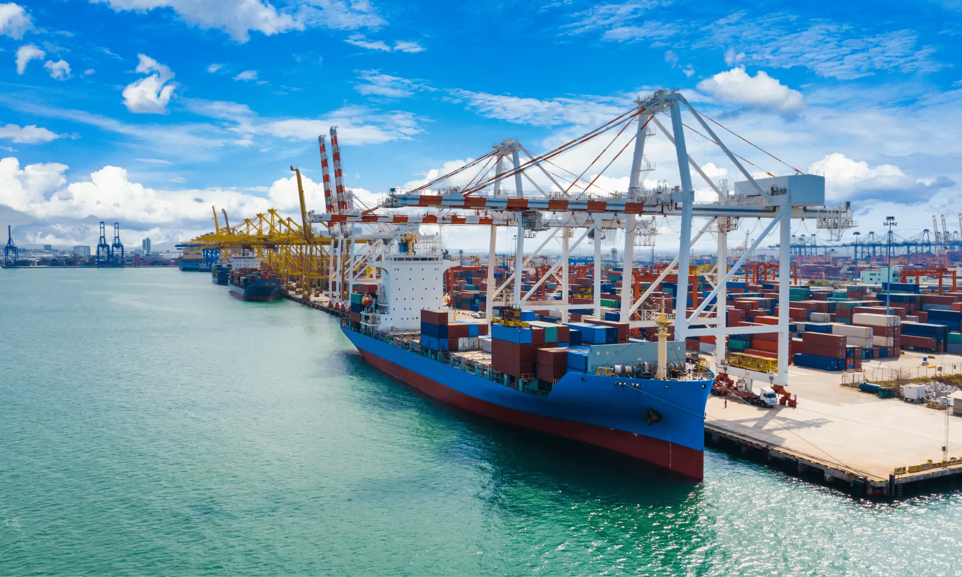
India sits at one of the most strategically important junctions in global trade. With roughly 7,500+ km of coastline and 12 major ports spanning its west and east coasts, the country acts as a natural bridge between two of the world's biggest trading regions — the Middle East/Europe corridor to the west, and the Far East/Pacific corridor to the east.
For anyone working in shipping and logistics, understanding this geography isn't just background knowledge — it directly shapes route planning, freight costs, transit times, and risk exposure.
Why Geography Matters in Shipping
- Route Planning & Transit Times — Which ports lie on the way, how long a voyage takes, and which corridor a shipment should move through.
- Freight Cost & Bunker Fuel — Distance and canal transits directly drive freight rates, fuel consumption, and surcharges.
- Choke Points & Geopolitical Risk — A handful of narrow straits and canals can disrupt world trade the moment they're blocked or unsafe.
- Documentation & Customs Zones — Knowing the region tells you the trade agreements, sanctions lists, and paperwork that may apply.
India at the Crossroads of Global Trade
| Metric | Figure |
|---|---|
| Share of India's trade volume moving by sea | 95% |
| Share of India's trade value moving by sea | 70% |
| Length of Indian coastline | 7,500+ km |
| Major ports on India's coasts | 12 |
Source: Government of India, Ministry of Ports, Shipping & Waterways
India's Own Gateways — West & East Coasts
West Coast
Faces the Arabian Sea, serving as the gateway to the Middle East, Africa, and Europe.
- Kandla / Deendayal (Gujarat) — India's largest port by cargo tonnage.
- Mumbai / JNPT–Nhava Sheva — India's busiest container gateway.
- Mundra (Gujarat) — Fastest-growing private container port.
- Kochi (Kerala) — Gateway for the southwestern coast.
East Coast
Faces the Bay of Bengal, serving as the gateway to Southeast Asia and the Far East.
- Kolkata / Haldia (West Bengal) — India's oldest operating major port.
- Visakhapatnam (Andhra Pradesh) — Leading east-coast cargo port.
- Chennai (Tamil Nadu) — Major container and automobile hub.
- Kamarajar / Ennore (Tamil Nadu) — Purpose-built for bulk and container cargo.
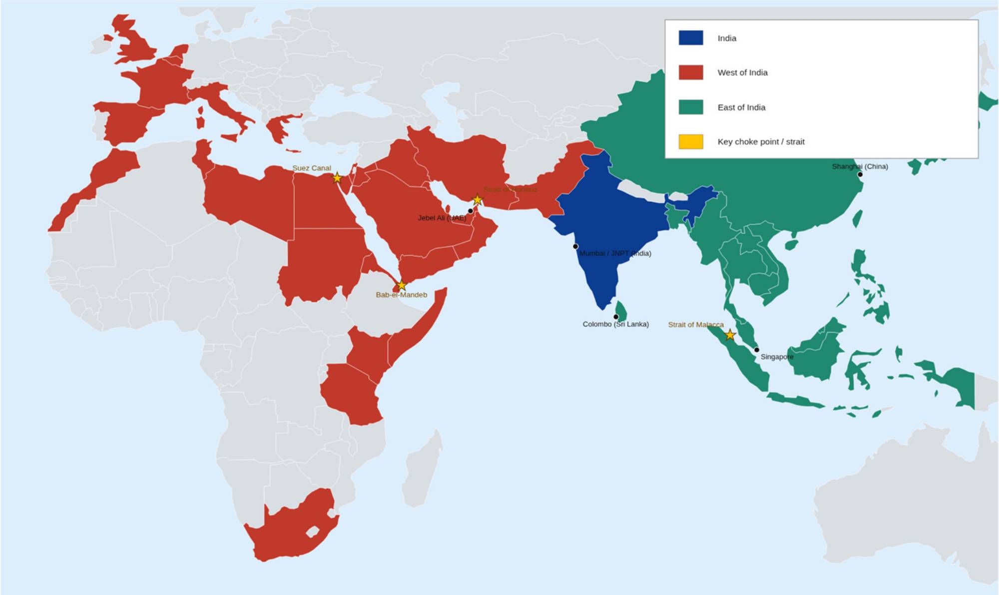
The Western Corridor: Arabian Sea → Persian Gulf → Red Sea → Suez Canal → Mediterranean → Europe
From India's west coast, ships cross the Arabian Sea toward Pakistan, the Persian Gulf, and East Africa, then continue through the Red Sea and Suez Canal into the Mediterranean and on to Europe — or round the southern tip of Africa via the Cape of Good Hope.
- Key waters: Arabian Sea, Persian Gulf, Red Sea, Mediterranean Sea
- Main destinations: Middle East, East Africa, Europe & onward to the Americas
- Shortest deep-sea corridor linking India to Europe — via the Suez Canal
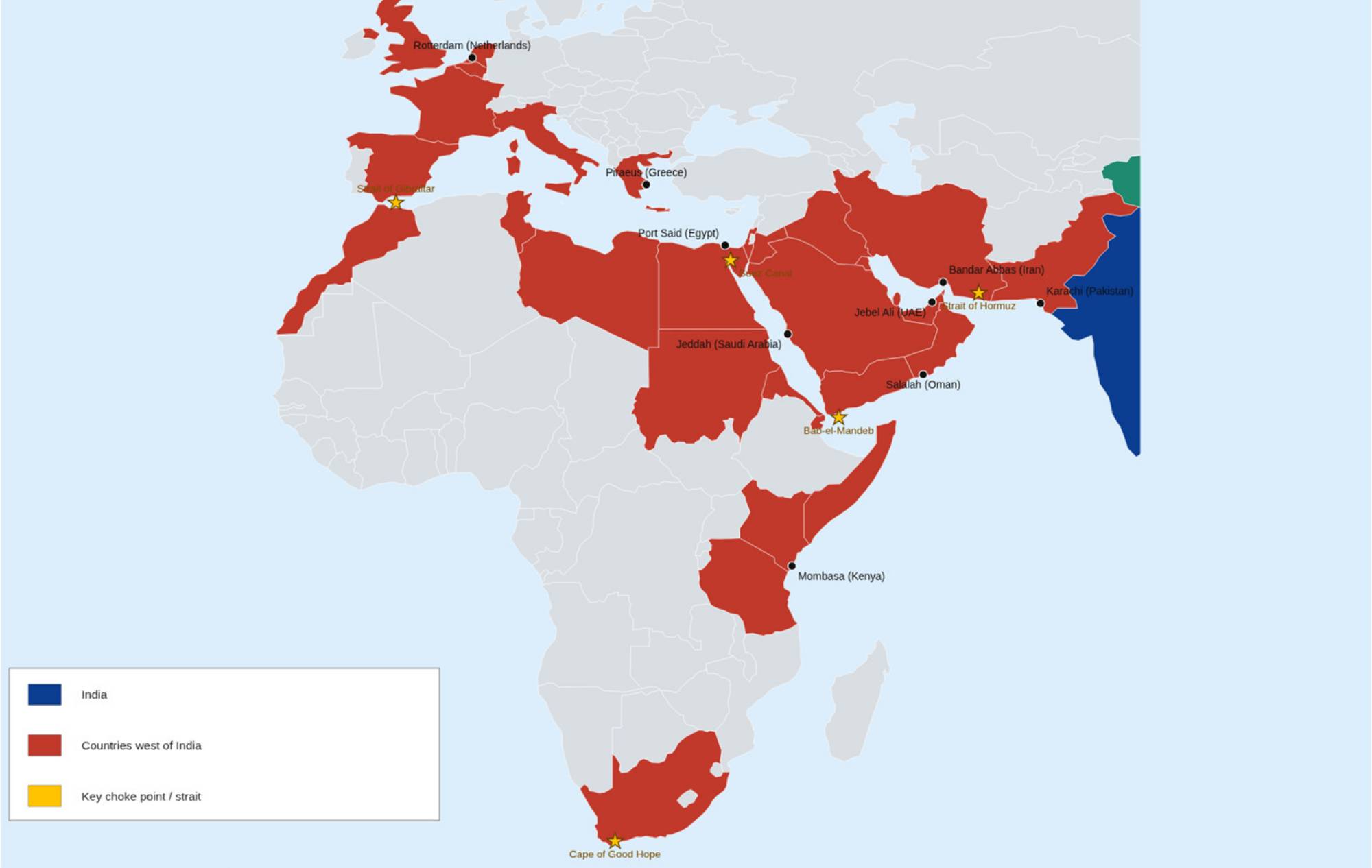
Key Countries & Ports to the West
| Country | Major Port(s) | Why It Matters |
|---|---|---|
| Pakistan | Karachi, Port Qasim | India's immediate western neighbour along the Arabian Sea coast |
| United Arab Emirates | Jebel Ali (Dubai) | The Gulf's #1 transshipment hub — among the world's 10 busiest |
| Oman | Salalah | Major transshipment & bunkering (refuelling) hub outside the Gulf |
| Saudi Arabia | Jeddah | Principal Red Sea gateway for the Kingdom |
| Egypt | Port Said / Alexandria | Guards the Suez Canal — the gateway to the Mediterranean & Europe |
| Kenya | Mombasa | East Africa's leading container gateway |
| Netherlands | Rotterdam | Europe's largest port — the far end of the westbound lane |
Choke Points on the Western Corridor
| Choke Point | Location | Significance |
|---|---|---|
| Strait of Hormuz | Between Iran and Oman | The only sea entrance to the Persian Gulf — roughly a fifth of the world's oil passes through it |
| Bab-el-Mandeb | Between Yemen and the Horn of Africa | The southern gateway to the Red Sea and the Suez Canal route |
| Suez Canal (Egypt) | Links Red Sea to Mediterranean | Avoids a journey around all of Africa — one of the world's busiest artificial waterways |
| Cape of Good Hope | Southern tip of Africa | Alternative route used when the Suez/Red Sea route is unsafe or blocked, adding 1–2 weeks |
Choke Points in the News — 2026
Red Sea / Bab-el-Mandeb
- Houthi attacks on commercial vessels since late 2023 have made many carriers avoid the Suez route entirely
- Many ships now reroute via the Cape of Good Hope — adding roughly 10–14 days and significant fuel cost per voyage
- A U.S. maritime advisory covering the Red Sea, Bab-el-Mandeb & Gulf of Aden remained active through much of 2026
Strait of Hormuz
- A 2026 US–Iran military standoff split traffic between a US-backed southern route and an Iran-prescribed northern route
- Daily transits fell by roughly 60% compared with pre-conflict levels, and many tankers disabled tracking (AIS) for safety
- Oil prices jumped from about $73 to over $90 a barrel as the market priced in the disruption risk
Sources: U.S. Maritime Administration advisory 2026-006; Al Jazeera (Aug 2026); Lloyd's List Intelligence Red Sea Brief (Aug 2026). Figures illustrative — always confirm current advisories before routing a live shipment.
The Eastern Corridor: Bay of Bengal → Strait of Malacca → South China Sea → Far East & Pacific
From India's east coast, ships cross the Bay of Bengal toward Sri Lanka, Bangladesh, and Southeast Asia, funnel through the Strait of Malacca into the South China Sea, and continue on to the Far East — China, Korea, and Japan.
- Key waters: Bay of Bengal, Andaman Sea, Strait of Malacca, South China Sea
- Main destinations: Southeast Asia, China, Korea, Japan & the wider Pacific
- Home to the world's busiest container ports — Shanghai, Singapore & Ningbo
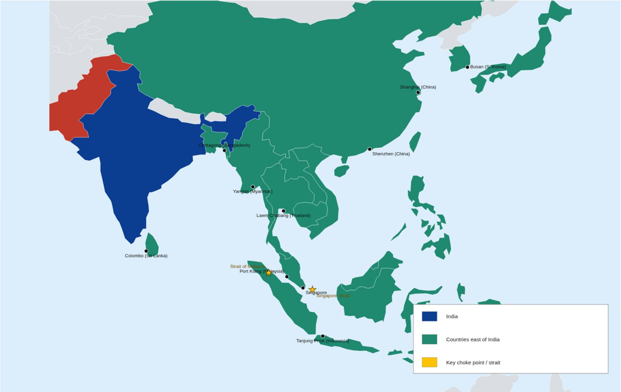
Key Countries & Ports to the East
| Country | Major Port(s) | Why It Matters |
|---|---|---|
| Sri Lanka | Colombo | The region's premier transshipment hub — a huge share of India's own containers route via Colombo |
| Bangladesh | Chittagong | India's eastern neighbour and a major regional trade partner |
| Malaysia | Port Klang, Tanjung Pelepas | Sits directly on the Strait of Malacca — key transshipment hub |
| Singapore | Singapore | World's #2 busiest container port; the region's top bunkering & transshipment centre |
| Thailand / Indonesia | Laem Chabang, Tanjung Priok | Gateways for Indochina and the Indonesian archipelago |
| China | Shanghai, Ningbo, Shenzhen | Home to the world's busiest container ports by a wide margin |
| South Korea / Japan | Busan, Tokyo/Yokohama | Advanced manufacturing hubs at the eastern end of the corridor |
The Strait of Malacca — Asia's Trade Lifeline
Roughly 25% of the world's traded goods — worth an estimated US$3.5 trillion a year — pass through this single strait between Malaysia, Indonesia, and Singapore. At its narrowest point (the Phillips Channel), it's only about 1.7 nautical miles (2.8 km) wide.
- Connects two oceans — Links the Indian Ocean (and India) to the South China Sea with no practical shortcut
- Few real alternatives — The Sunda and Lombok Straits exist further south but add significant sailing distance and time
- Everyone's shipment passes near it — Almost every India-to-Far-East voyage, and vice versa, funnels through this corridor
Typical Transit Times From Mumbai
| Route | Approx. Transit | Corridor |
|---|---|---|
| Mumbai (JNPT) → Jebel Ali, UAE | 4–6 days | West |
| Mumbai (JNPT) → Colombo, Sri Lanka | 2–3 days | South / East |
| Mumbai (JNPT) → Singapore | 7–9 days | East — via Malacca |
| Mumbai (JNPT) → Shanghai, China | 20–24 days | East — via Malacca |
| Mumbai (JNPT) → Rotterdam, Netherlands | 18–22 days | West — via Suez |
Approximate ocean transit times only — actual schedules vary by carrier, vessel routing, port congestion, and season. Excludes pre-carriage, customs clearance, and inland transit.
Key Takeaways
- India sits at the hinge between two great trading worlds — the Arabian Sea/Middle East/Europe corridor to the west, and the Bay of Bengal/Far East corridor to the east
- Almost all of India's trade volume (95%) and most of its value (70%) moves by sea — geography is core business, not background knowledge
- A short list of choke points — Hormuz, Bab-el-Mandeb, Suez, Malacca — can each disrupt world trade on their own
- Colombo and Singapore matter to India precisely because India still relies on them for transshipment
- Geography drives real decisions in shipping: routing, transit time, freight cost, and risk